Update Regional Violence
June 10, 2025 · 4 min reading
Israel focuses on Gaza, but wages war on West Bank, Syria and Lebanon
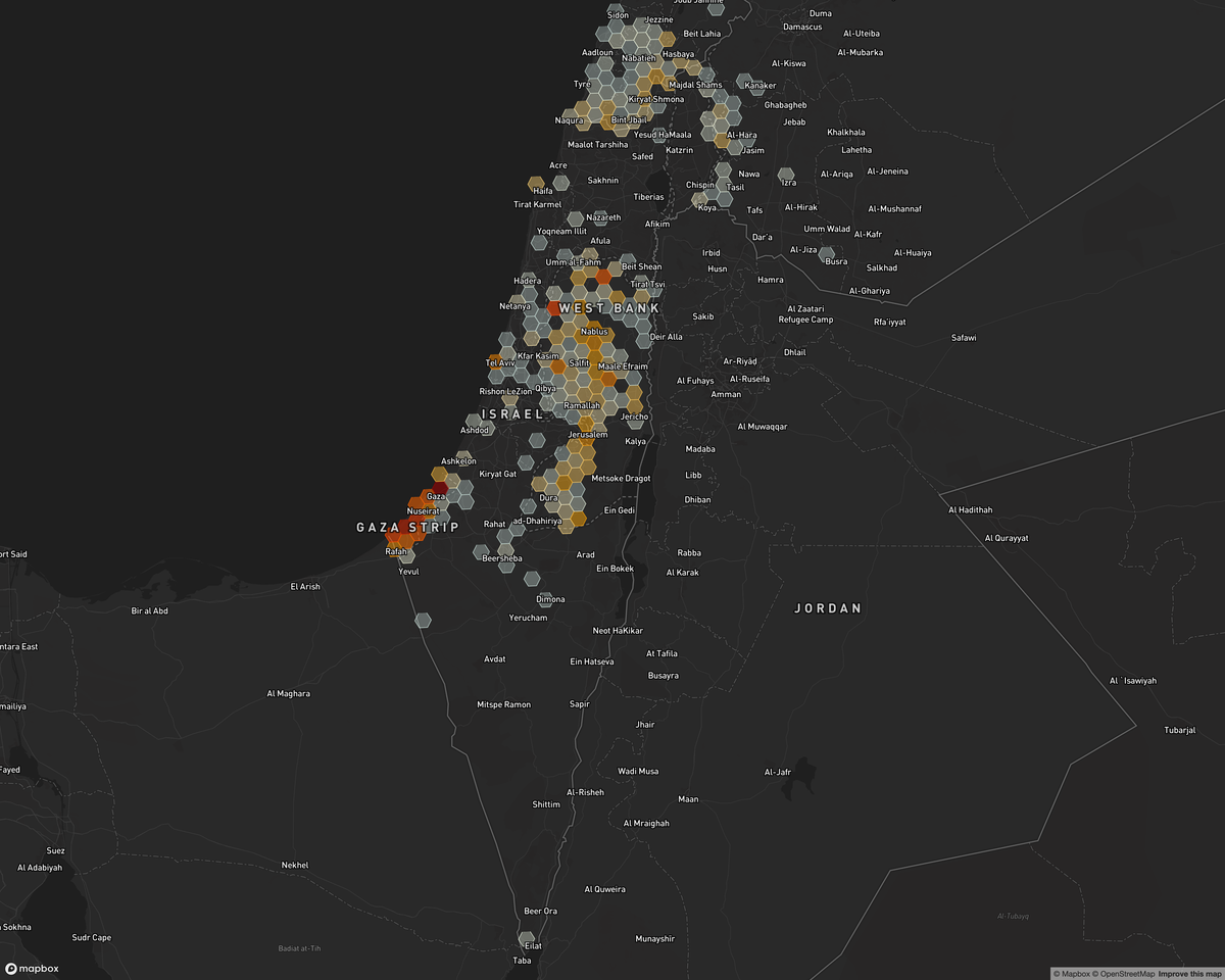
Since the mid-March collapse of Gaza’s ceasefire, Israel’s assault has killed or injured tens of thousands, crushed what remains of vital infrastructure, and forced more than 640,000 people into an ever-shrinking patchwork of so-called ‘safe zones.’ Even ‘humanitarian aid’ distribution sites and food lines have been made fatal, prompting UN calls for an independent inquiry. Meanwhile, on the other side of the Green Line, the Israeli cabinet rubber-stamped 22 new settlements—and legalised nine outposts—while bulldozers resumed razing homes in Nur Shams refugee camp, Tulkarm. Israel’s bombardment of Gaza and its acceleration of land grabs in the West Bank reveal a single, coordinated strategy of expulsion and enclosure that is reshaping Palestinian life from river to sea.

Cody O'Rourke
cody@goodshepherdcollective.org

Report Generated: 6-10-2025
Date Range: Last 30 Days
Data Summary
- Total Events: 2132
- Total Fatalities: 1898
Events by Country
- Historical Palestine: 1898
- Lebanon: 182
- Syria: 52
Narrative Summary
Since Israel abandoned and sabotaged the ceasefire on the night of March 17, 2025, Israeli military operations have intensified, killing and wounding tens of thousands of Palestinians and inflicting still more devastation on already-fragile civilian infrastructure. OCHA reports that 82 percent of the Strip now lies inside militarized or evacuation zones, forcing families into ever-smaller pockets of starvation and chaos; more than 640,000 people have been displaced yet again since mid-March, including over 200,000 between May 15th and June 3rd alone. UNRWA Commissioner-General Philippe Lazzarini has warned that even the scramble for much-needed aid has become “a death trap,” while UN Secretary-General António Guterres has demanded an independent investigation after repeated incidents in which Palestinians were killed or injured while seeking food and relief.
Across the occupied West Bank, Israeli authorities have simultaneously entrenched control by approving 22 new settlements on 29 May, formalizing nine previously unauthorised outposts and accelerating land confiscation. The crackdown extends to refugee camps: after a May 1 order to raze 106 homes in the Nur Shams and Tulkarm camps, bulldozers returned to Nur Shams on May 29, reigniting demolitions that had paused only briefly. These parallel fronts—in Gaza and the West Bank—underscore a coordinated strategy of displacement, enclosure, and settlement expansion that is inherent within the processes of settler-colonialism and indigenous erasure.
Event Details
Historical Palestine
1. 06.06.2025 – Al Qararah
- Description: Israeli occupation engineers systematically demolished residential blocks in Al Qararah, expanding a depopulated buffer zone; no casualties reported.
- Source: Quds News Network
2. 06.06.2025 – Gaza – At Tuffah
- Description: Israeli forces levelled apartment towers in the At Tuffah district of Gaza City, furthering their scorched-earth campaign; no casualties recorded.
- Source: Quds News Network
2. 06.06.2025 – Khan Yunis – Al Kateebeh
- Description: Israeli forces blew up homes north of Khan Yunis to clear space for military entrenchment, displacing yet more families; no injuries noted.
- Source: Quds News Network
4. 06.06.2025 – Jabalya Camp
- Description: Israeli forces detonated residential structures on the eastern edge of Jabaliya refugee camp in a continuing strategy of collective punishment; no casualties documented.
- Source: Quds News Network
Lebanon
1. 06.06.2025 – Al Wazzani
- Description: Movement of forces: On 6 June 2025, an Israeli detachment crossed into Lebanese territory, building earthen barriers near Al Wazzani (Hasbeiya). No casualties were reported.
- Source: AlManar TV
2. 06.06.2025 – Kfar Kila
- Description: Other: An Israeli drone dropped a stun grenade over Kfar Kila, Lebanon (Marjayoun). No injuries reported.
- Source: AlManar TV; El Nashra; Murr TV; National News Agency Lebanon
3. 06.06.2025 – Aita ash-Shaab
- Description: Israeli forces fired heavy machine-gun rounds into the outskirts of Aita ash-Shaab (Bint Jbeil), Lebanon. No casualties.
- Source: AlManar TV; Lebanon24; National News Agency Lebanon
4. 06.06.2025 – Rmaysh
- Description: Israeli troops sprayed machine-gun fire toward Rmaysh (Bint Jbeil), Lebanon; no casualties recorded.
- Source: AlManar TV; El Nashra; National News Agency Lebanon
5. 06.05.2025 – Qlayaa
- Description: Lebanese Army engineers safely detonated an unexploded Israeli air-dropped bomb in Qlayaa (Marjayoun).
- Source: El Nashra; Lebanon24; National News Agency Lebanon
Syria
1. 06.06.2025 – Kodneh
- Description: Israeli forces in five vehicles entered Abu Qbes near Kodneh (Quneitra), Syria, reinforcing forward positions; no casualties.
- Source: SOHR
2. 06.05.2025 – Majduliya
- Description: Seven Israeli vehicles advanced to the outskirts of Majduliya (Quneitra), Syria for reconnaissance; no casualties.
- Source: SOHR
3. 06.04.2025 – Rabiah
- Description: An Israeli drone strike on an ammunition depot near Rabiah (Hama) killed 8 Syrian civilians, including 3 women, and injured several others.
- Source: Alkhabour; Halab Today; Liveuamap; North Press Agency; SOHR; Syria TV; The Euphrates Post
4. 06.04.2025 – Jbata Elkhashab
- Description: Roughly 50 Israeli soldiers raided Jbata Elkhashab (Quneitra), Syria, imposing a siege and house-to-house searches; no casualties reported.
- Source: SOHR
5. 06.04.2025 – Breiqa
- Description: Israeli artillery from Tall al-Ahmar shelled the area between Breiqa and Kodneh (Quneitra), Syria; casualty figures unknown.
- Source: SOHR
Data source: Armed Conflict Location & Event Data (ACLED).
All analysis and framing provided by the Good Shepherd Collective.
Support
The Good Shepherd Collective rejects the model of large grants from liberal institutions because of the ways it can shape the work. Instead, we premise our work in the financial investments from individuals who believe in the future we're trying to build. Consider becoming a monthly donor.
Donate